Ecological restoration & geomatics · Banff

Nerd for hire.

Ecological restoration, vegetation monitoring and applied geomatics. From what's happening on the ground to what the data says.

  • Certified Ecological Restoration Practitioner
  • M.G.E.M., UBC Forestry
  • Transport Canada RPAS Advanced
  • 10+ years in the field
# yak.py
ecology   = {"restoration", "vegetation", "fieldwork"}
geomatics = {"maps", "data", "drones", "automation"}
niche     = ecology | geomatics

# questions first
project = scope(problem, using=niche)
deliver = {"plans", "reports", "tools", "answers"}
# one person, the whole picture

Services

Support at any stage.

01 · Early guidance

Advisory

Advice, second opinions, and another experienced set of eyes when you don't need to hand over the whole project. I can help shape the approach, work through a problem with your team, or build capacity for next time.

More on Advisory →

02 · Design & approvals

Planning & Design

Restoration planning built around the site and what it will actually take to deliver the work. That can include revegetation plans, protocols, plant sourcing, and the technical pieces behind them.

More on Planning & Design →

03 · Field & evaluation

Assessment & Monitoring

Figure out what's there, what's changing, and whether the work is doing what it was meant to do. I can take on the field assessment, the remote-sensing analysis, or build a monitoring approach that uses both.

More on Assessment & Monitoring →

04 · Geomatics & data

Geomatics, Data & Automation

Maps, analysis, remote sensing, data workflows, and small tools built around the problem you're actually trying to solve. Sometimes that's a one-off analysis; sometimes it's turning a repetitive process into something that runs itself.

Have data you want to use? →

Who I work with.

Environmental & construction firms

Fewer surprises between the bid and the sign-off.

Your team may already have the people and experience to deliver most of the project. I can step in when something falls outside the usual scope, whether that means bringing restoration experience to a challenging site or finding a better way to mobilize field data as it's collected.

Agencies & conservation organizations

From fieldwork to something you can use.

High standards, limited staff time. Give me the problem or the idea and I can take on the work around it, whether that means getting out in the field, working through the data, or building the thing your team needs. I can carry it through without creating another project for your staff to manage.

Not one of these? Let's talk anyway.

Need some extra senior ecology or GIS capacity without another full-time position? I can plug into a single project or provide ongoing part-time support, whatever the season calls for.

How I work

On your team, not across the table.

One window.

One point of contact. Nothing gets lost in internal handoffs or translation. You're hiring me, and you work with me directly.

Questions first.

What's happening on the site, what information you already have, what useful data I can find elsewhere, which approvals matter, and what you need at the end. Then we scope the work.

Technical, made useful.

I can handle the technical detail, but what comes back should make sense to the people who actually need to use it.

The answer isn't always yes.

If I don't think something is going to solve the problem, I'll say so. The goal is to get the work right, not make it bigger.

Services in detail

Fewer surprises later.

You need an expert in the room.

I can help work through the ecology, the approach, and what reviewers are likely to expect. I've spent years reviewing and delivering restoration plans from the land-manager side, so I know where questions tend to come up.

You want the capability in-house.

Advising, mentorship, and training for your staff, so the project team, agency, and contractor are working from the same page. The aim is that your people need me less next season, not more.

Examples

  • Design and approach review
  • Regulatory interpretation memo
  • Staff training and mentorship
  • Workshop facilitation

Certified Ecological Restoration Practitioner (CERP).

Focus Area · Vegetation Monitoring

The whole site from above.
The truth from the ground.

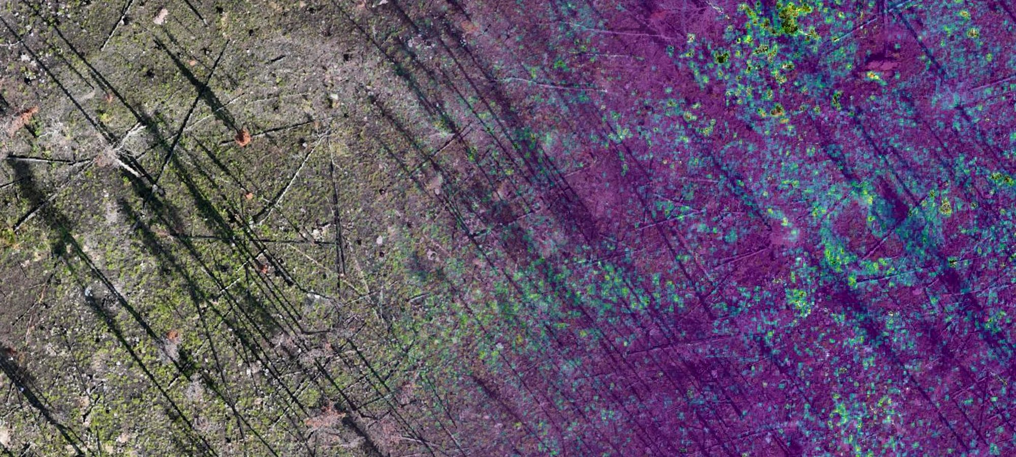
Field ecology, satellite, drone and LiDAR all have a place. I use the mix that fits the question, then check what the data says against what's actually happening on the ground.

Aerial view of a recovering burned site, shifting from true colour into a vegetation index.

Scale

Right sensor, right scale

Field, satellite, drone or LiDAR, used where each actually adds something.

Measure

Metrics that mean something

Cover, composition, condition and change measured around the question you need answered.

Validate

Ground truth

Remote-sensing results checked against field observations, with unexpected patterns flagged for a closer look.

Applications

Restoration, wildfire and WRR, invasive vegetation, riparian and wetland recovery, and long-term landscape change.

Focus Area · Invasive & Non-Native Vegetation

You can't fight every weed.
Pick the fights you can win.

A big part of weed management is knowing where to spend the effort. I use field knowledge, invasion biology, regulation and spatial data to set those priorities and track what happens next.

Prioritize

Decide where to act

Not every species or site needs the same response. I prioritize based on risk, spread, legal obligations and whether control is likely to work.

Track

Know what happened

Keep surveys, treatments and follow-up in one practical workflow so you can see what was done and what changed.

Connect

Keep the data useful

Field records should still be useful after the season ends. I keep the data clean enough to map, report and move into regional databases without rebuilding it every year.

01 / 02

Get in touch

Tell me about the project.

It doesn't need to be fully figured out. Send me the site, the issue, or the idea you're working through and I'll tell you if I think I can help.

Let's start with a call, or a walk if you're in the Bow Valley.

LinkedIn

Brian Yakiwchuk

Serving

Western Canada: field and restoration work
Remote: geomatics and data work